NASA LBA-ECO
Spatial Integration of Regional Carbon Balance in Amazônia
NASA 2003 – 2005
 We propose a 3-year continuation of our investigation of processes that control land-atmosphere CO2 exchange in Amazônia, using a suite of numerical models to extrapolate local results to regional and Basin scale. We emphasize three key areas of research: (1) evaluation of our models across a range of spatial and temporal scales, from local fluxes and isotope ratios to field campaigns in the area of the Flona Tapajos, to large regions sampled by airborne experiments; (2) a collaborative investigation of the effects of surface water and seasonally inundated land on exchanges of energy, water, and CO2; and (3) estimation of regional and Basin-scale carbon balance on seasonal, annual, and interannual time scales by inversion of atmospheric data using tracer transport modeling.
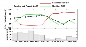
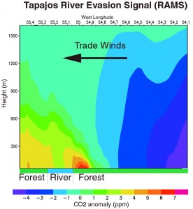
 Evaluation of a new version of the ecophysiology model SiB will be by direct comparison to measured fluxes of heat, water, and carbon; canopy profiles of CO2; and the stable isotope ratios of fluxes and stored carbon. The model has been coupled to a mesoscale atmospheric model (RAMS), and will also be evaluated by comparison to observed weather and to concentrations and δ13C of CO2 in the regional atmosphere, as measured by other teams from towers and airborne platforms. The evasion of CO2 from the Tapajos River will be investigated in a set of collaborative field campaigns in which other teams will document local fluxes and isotope ratios of CO2 from the River and from soils and vegetation in different ecosystems. We will then use the coupled SiB2-RAMS model to propagate these fluxes through the regional atmosphere and predict variations in concentrations in space and time and compare to measurements made by other teams from boats and aircraft. At the larger regional and Basin scales, the influence of surface water and inundated land will be investigated by prescribing the areal extent of these surfaces in RAMS from products developed by other teams using radar and microwave imagery. Energy, water, and CO2 fields simulated using these fields will be compared to those simulated in a control experiment using classifications based on AVHRR imagery, and to observed meteorology and trace gas concentration measured during the COBRA-BRAZIL campaigns. We have developed a synthesis inversion method for estimation of area-averaged surface fluxes from measured CO2 at regional scales by including lateral inflow fluxes and initial conditions in the calculation. We will extend these methods to use multiple tracers (CO, δ13C) and apply them in the Tapajos intensives, over large regions for COBRA-BRAZIL, and to the entire Basin using a suite of global transport models. These methods yield quantitative estimates of both the area- averaged flxu and the uncertainty in these fluxes.
This investigation directly addresses LBA-E questions CD-Q1 (“What is the (climatically driven) seasonal and interannual variability of the carbon dioxide flux between the atmosphere and different land cover/use types?”); CD-Q3 (“What are the relative contributions of fluxes from natural and disturbed ecosystems to the net Amazônia-wide flux?”); and ND-Q5 (“What is the importance of periodically “wet” environments for the land and atmospheric balances of nutrients, carbon dioxide, trace gases, and water and energy on multiple scales?”). The proposed research addresses NASA Earth Science Enterprise questions of variability in the carbon fluxes across Amazônia in space and time; forcing of these variations by climate and land use, the response of terrestrial ecosystems and the atmosphere to this forcing, and prediction of the consequences for CO2 concentrations and stale isotope ratios.


