Top-down / Bottom-up integration
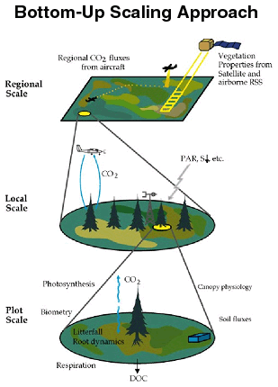
 Carbon cycling on land can be studied in the field, allowing the processes controlling sources and sinks to be quantified locally.
Important research methods include laborious sampling and inventory of biomass and other ecological variables across landscapes, and more recently ecosystem-level flux estimation by eddy covariance techniques. The trouble with this approach is that one can never know whether a particular study site is broadly representative of similar sites. Extrapolation to regional or global scales from such local studies is based on tApril 28, 2006 3:41 PM embodied in simulation models. These models can then be used to estimate spatial and temporal variations in CO2 uptake and release over large areas, if appropriate “input” data sets (e.g., vegetation and soils maps, weather data) are available. The investigation of local processes, construction of models, and extrapolation with spatial data to larger scales has been called the “bottom-up” approach to carbon cycle science.
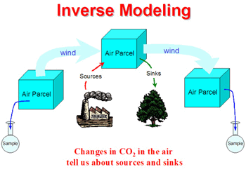
Alternatively, carbon sources and sinks of can be estimated from patterns of variability in atmospheric CO2 that result from them. This typically involves tracking the motion of the air, and measuring changes in CO2 and other trace gases in space and time to estimate the net source or sink, essentially by mass balance. This set of methods is broadly known as “inverse modeling,” because it involves observing an “effect” (changes in atmospheric CO2 concentrations) and then inferring a “cause” (sources and sinks at the surface).
This kind of analysis can be applied at a number of scales in space and time, depending on the type of atmospheric observations collected. Global inverse calculations are based on flask samples of air collected weekly at about 100 sites around the world, and can resolve annual and seasonal net carbon sources and sinks for regions the size of continents and ocean basins. Regional data collected during campaigns by aircraft or tall towers can be inverted to obtain net sources and sinks for the study area over short periods of time. These methods have been called “top-down,” in that they provide independent estimates of net sources and sinks over large areas in the time mean, without knowing any details about finer-scale variability or the underlying processes that cause the fluxes. The advantage of top-down studies is that fluxes are estimated for large representative regions. The disadvantage is that they provide little or no information about the underlying processes, and so don’t contribute much to understanding and prediction.
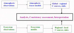
The top-down and bottom-up approaches are thus complementary, and we seek to combine them to understand and quantify carbon sources and sinks in a “multiple constraint” approach. The idea is to work with other researchers who study ecosystem cycling of carbon, water, and energy at local scales in a range of very different ecosystems. We test our ecophysiology model (SiB2) against measured fluxes at each site, and make improvements as necessary. Local testing is being done at boreal forest sites in Canada, temperate forest sites in Wisconsin, agricultural and native prairie sites in Oklahoma and Kansas, and both forested and deforested sites in tropical Brazil. We have also coupled SiB to the CSU Regional Atmospheric Modeling System (RAMS). This allows us to evaluate both the simulated weather and regional distributions of ecosystem fluxes of carbon, water, and energy during intensive field campaigns. Additionally, mesoscale simulations of atmospheric transport in RAMS are used to perform inverse analyses of concentration measurements to obtain independent estimates of net fluxes over large areas, which are then compared to the process-based, satellite-extrapolated, “pixel-by-pixel” estimates made using SiB.
The locally- and regionally-evaluated model is then used to analyze the carbon cycle globally, both in “diagnostic” mode driven by observed weather and satellite imagery, and also fully coupled to the CSU General Circulation Model (BUGS). This allows retrospective analyses of carbon cycle variability in a realistic framework tied to observations and also research on the interactions between biology, chemistry, and physics that define the carbon cycle and the climate system.
These investigations have highlighted the importance of interactions between biology and meteorology which influence the spatial distribution of CO2 in a process that has been dubbed the “rectifier effect.” Our local to regional investigations in well-observed field areas allow us to evaluate the realism of these effects in the transport models used for inversions. We have coordinated a major international inversion intercomparison experiment (TransCom). Analysis of the TransCom results has led to a better understanding of the need for more observations of atmospheric concentration over the continents, and we are using our various modeling tools to help design and prioritize the deployment of improved observing systems. We are developing new methods for mesoscale and global inverse analysis of CO2 fluxes that will be needed to use the new data as they come online.
These analyses have been helpful in planning new US initiatives for studying the carbon cycle at the global (US CCSP) and continental scales (the North American Carbon Program, NACP), and also in international planning efforts (through the Integrated Global Observing Systems, IGOS-TCO).
A particularly exciting development is the possibility of obtaining global atmospheric CO2 measurements from spaceborne sensors. We are working on methods of applying such data in inverse analysis and data assimilation systems. We hope to contribute to the development of a new generation of Earth System Data Assimilation methods over the next decade, which will bring together global observations of the land, oceans, and atmosphere into fully coupled dynamical models for the first time.


