NASA Carbon Satellite
Global and Regional Carbon Flux Estimation Using Atmospheric CO2 Measurements from Spaceborne and Airborne Platforms
NASA 2003 – 2005
We propose to develop methods for determination of surface sources and sinks of atmospheric CO2 using inverse modeling from spatially dense atmospheric data anticipated to be available in the near future. These will include ubiquitous column CO2 estimates made from infrared spectra measured by spaceborne sounders (AIRS in 2001, IASI in 2003), and high-precision measurements made from tall towers and aircraft over the continents as well as more traditional flask sampling. We anticipate that these data could be used to provide fully populated grids for global flux estimation, beginning with very low precision but improving over time. Although they provide a tremendous opportunity for the study of the global carbon cycle, these data challenge us to develop new methods to extract the information.
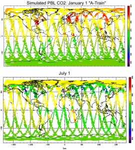
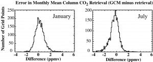
We will develop algorithms for both estimation of CO2 mixing ratio from spaceborne measurements and for quantitative estimation of surface fluxes from concentration data by tracer transport inversion. The Colorado State University (CSU) General Circulation Model (GCM) will be used to simulate self-consistent hourly 3D grids of CO2 temperature, water substance and other meteorological variables. The CSU GCM is fully coupled to the Simple Biosphere Model (SiB2), which predicts exchanges of CO2 with the vegetated land surface every few minutes and has been favorably compared to field data at many locales and scales. We will compute radiances at the top of the atmosphere in thousands of relevant bands in the infrared and fly “virtual satellites” through the model to sample these radiances. We will develop and test algorithms for CO2 estimation in the column mean and in several atmospheric slabs from these simulated radiances, including cloud masking, water vapor interference, and a realistic diurnal and seasonal cycle. We will then use atmospheric inverse methods to estimate regional CO2 fluxes and uncertainty in these fluxes on a monthly basis from the concentration estimated radiometrically. We will also develop and test possible future strategies for spaceborne CO2 sensors using dedicated hardware, including documentation of requirements for accuracy, sampling frequency, orbital considerations, etc.
 We will also propose three “nested” regional experiments in the context of the hypothesized ubiquitous satellite CO2 data. These will be high-resolution pseudo-data continents (North America, South America, and sub-Saharan Africa) simulated with a mesoscale model (SiB-RAMS) on a 40 km grid. We will sample these fields with “pseudo-aircraft” and “pseudo-tall-towers,” and provide guidance about sampling strategies to provide maximum carbon budget constraints with limited resources. These regional optimization studies are seen as collaborative with regional aircraft sampling campaigns proposed in these regions (COBRA and LBA). The Amazon inversions will also require development of improved representations of transport by organized cumulus convection.


