NASA LBA-Ecology
Spatial Integration of Regional Carbon Balance in Amazônia
NASA 1998-2003
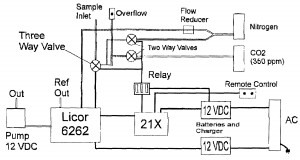
 We propose a three-year research program to estimate the basin-scale carbon balance of Amazônia, using a combination of data collected by flux towers, atmospheric data collected from light rental aircraft, numerical modeling of ecosystem carbon flux and regional atmospheric circulation, remote sensing, and geographic information systems. Tower flux data from sites in intact forest, regrowing forest, pasture, and savanna, will be used to calibrate a model of ecosystem physiology and biogeochemistry (based on the component models SiB2 and CASA) for each major cover type in the region. This model will be coupled to a mesoscale atmospheric model (RAMS), to investigate the propagation of the “signal” of terrestrial carbon flux into the local and regional atmosphere. Light aircraft will be used to estimate local boundary-layer budgets of CO2 and its stable isotopes, and these data will be used in conjunction with the model to estimate carbon budgets of each cover type over much larger areas than is possible from the towers. An improved ecosystem model will then be applied across the basin using remotely sensed data and a GIS, to calculate the spatial structure of ecosystem carbon flux throughout the year. These estimated fluxes will be used in the mesoscale atmospheric model to predict 3- dimensional fields of CO2 and δ13C, which can be compared to data collected by later aircraft campaigns such as LBA-CLAIRE or TRACE-B, when they become available. It is hoped that our results will allow reliable carbon budget estimation in other regions from EOS data in the future using relatively inexpensive aircraft sampling programs.


